AerialMegaDepth
AerialMegaDepth: Learning Aerial-Ground
Reconstruction and View Synthesis
Carnegie Mellon University
(* denotes equal contribution/advising)
IEEE/CVF Conference on Computer Vision and Pattern Recognition (CVPR) 2025
TL;DR: A scalable data generation framework that combines mesh-renderings with real images, enabling robust 3D reconstruction across extreme viewpoint variations.
![]()
AerialMegaDepth: A hybrid varying-altitude 3D dataset combining MegaDepth images with geospatial mesh renderings, featuring 132K images across 137 scenes with camera intrinsics, poses, and depths in a unified coordinate frame.
Overview
Learning robust 3D reconstruction across ground-to-aerial views is limited by the lack of co-registered ground-aerial training data, which is hard to collect at scale and often requires manual effort or specialized sensors. We propose a scalable framework that combines pseudo-synthetic views rendered from geospatial 3D meshes (e.g., Google Earth) with real ground-level images (e.g., MegaDepth) in a unified coordinate frame. This hybrid strategy reduces the domain gap in mesh renderings and provides diverse, viewpoint-rich supervision for multi-view tasks.
Examples of our generated cross-view geometry data, including co-registered pseudo-synthetic aerial and real ground-level images
Our Data Generation Framework
Improving aerial-ground pose and geometry estimation
By fine-tuning DUSt3R with our dataset, we observe significant improvements in handling the extreme viewpoint differences between aerial and ground-level imagery compared to the baseline DUSt3R model.
Improving aerial-ground correspondence matching
Fine-tuned MASt3R produces accurate and robust feature matching across ground-aerial pairs with extreme viewpoint changes (correspondences extracted via reciprocal-NN from MASt3R's local feature maps).
Co-registering non-overlapping ground images with aerial context
Despite the lack of overlap among ground images, incorporating an aerial image can effectively serve as a "map", significantly improving accuracy when finetuned on our cross-view training data.
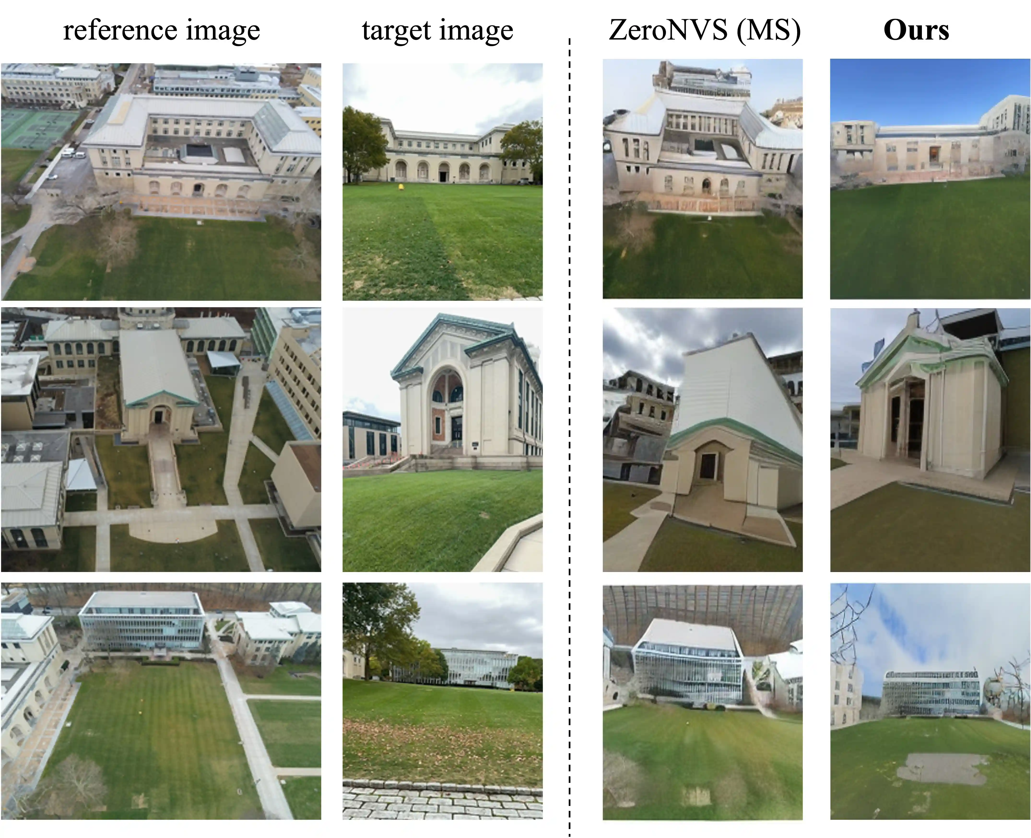
Improving aerial-to-ground novel-view synthesis
ZeroNVS[1] finetuned on our dataset shows notable improvements in visual quality and viewpoint accuracy when synthesizing extreme aerial-to-ground viewpoint changes.
[1] ZeroNVS: Zero-Shot 360-Degree View Synthesis from a Single Image. Sargent et al., CVPR 2024.
BibTex
If you use this work or find it helpful, please consider citing:
@inproceedings{vuong2025aerialmegadepth,
  title={AerialMegaDepth: Learning Aerial-Ground Reconstruction and View Synthesis},
  author={Vuong, Khiem and Ghosh, Anurag and Ramanan, Deva and Narasimhan, Srinivasa and Tulsiani, Shubham},
  booktitle={Proceedings of the IEEE/CVF Conference on Computer Vision and Pattern Recognition},
  year={2025},
}
Acknowledgements: This work was supported by Intelligence Advanced Research Projects Activity (IARPA) via Department of Interior/Interior Business Center (DOI/IBC) contract number 140D0423C0074. The U.S. Government is authorized to reproduce and distribute reprints for Governmental purposes notwithstanding any copyright annotation thereon. Disclaimer: The views and conclusions contained herein are those of the authors and should not be interpreted as necessarily representing the official policies or endorsements, either expressed or implied, of IARPA, DOI/IBC, or the U.S. Government.