The United Kingdom (officially the United Kingdom of Great Britain and Northern Ireland) includes England, Scotland, Wales, and Northern Ireland. Occupying the northern third of the island of Great Britain, the kingdom of Scotland has shared its monarch with England since 1603 and has been part of the United Kingdom since 1707. The coastline of the country is deeply cut by inlets, and there are more than 790 islands. The country has a long and distingushed maritime history; many of the most famous British captains and navigators have been Scots.
Scotland was divided historically into 34 counties; the counties no longer have any administrative function although they continue to have cultural significance. Most of them survive as lieutenancy areas, the areas used for the ceremonial lord-lieutenants, the monarch's representatives. Since 1996 the country has been divided into 32 council areas for the purposes of local government. This page covers lighthouses of northern Scotland in the Highland Council Area. The council area, by far Britain's largest, is the heart of the Scottish Highlands, including the northern third of the Scottish mainland as well as the large Isle of Skye, the so-called Small Isles, and a number of other islands at the northern end of the Inner Hebrides. It includes large portions of the historic counties of Inverness-shire and Ross and Cromarty, all of Caithness, Nairnshire and Sutherland, and small parts of Argyll and Moray.
The Northern Lighthouse Board  , established by an act of Parliament in
1786, manages the major lighthouses of Scotland and the Isle of Man. For
five generations, engineers of the Stevenson family created for the Board
a network of elegant and durable lighthouses famous around the world.
Most of these lighthouses remain in service today.
, established by an act of Parliament in
1786, manages the major lighthouses of Scotland and the Isle of Man. For
five generations, engineers of the Stevenson family created for the Board
a network of elegant and durable lighthouses famous around the world.
Most of these lighthouses remain in service today.
The Scots word loch is used both for lakes and for inlets of the sea; a firth is a larger bay or strait, kyle is a strait or channel, and a mull is a rounded headland. Travelers in the Highlands, especially
the western part, will find Scottish Gaelic in frequent use. The Scottish
Gaelic phrase for a lighthouse is taigh
solais; eilean is
an island, sgeir is a skerry or rock, kyle is a strait, and rubha or
àird is a cape or promontory.
ARLHS numbers are from the ARLHS
World List of Lights. Admiralty numbers are from Volume
A of the Admiralty List of Lights & Fog Signals. U.S. NGA numbers
are from Publication 114.
- General Sources
Northern Lighthouse Board - Lighthouse Library
- The Board's web site includes information and photos for many of the
lighthouses.
- Michael's Comprehensive List of Scottish Lights
- Data and photos posted by Michael Spencer.
- Lighthouse Archives
- Lighthouse information from LighthouseAccommondations.uk.
- Online List
of Lights - Scotland
- Photos by various photographers posted by Alexander Trabas.
- Lighthouses in Highland Council Area
- Photos available from Wikimedia; many of these photos were first posted on Geograph.org.uk.
- World of Lighthouses - Scotland
- Photos by various photographers available from Lightphotos.net.
- United Kingdom Lighthouses
- Aerial photos posted by Marinas.com.
- Britische
Leuchttürme auf historischen Postkarten
- Historic postcard images posted by Klaus Huelse.
- The Stevensons
- The history of Scotland's remarkable family of lighthouse engineers.
- GPSNauticalCharts
- Navigational chart information for northern Scotland.
Rua Reidh Light, Gairloch, June 2022
Google Maps photo by Andrea Hielscher
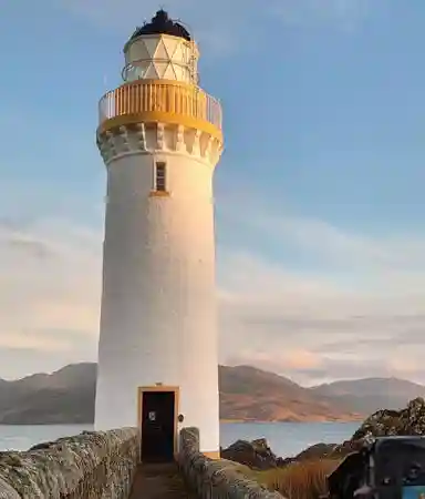
Cape Wrath Light, Durness, May 2023
Instagram photo by Stefan Loose
Lochaber (Mainland West Coast) Lighthouses
- The southern portion of the Lochaber area was historically in the county of Argyll; the area north of Ardnamurchan was in Inverness-shire.
- [Rubha Cuil-Cheanna]
- 2021. Active; focal plane 12 m (39 ft); flash every 2 s, white, red or green depending on direction; also a passing light, two green flashes every 8 s. 5.5 m (18 ft) square skeletal tower clad with white aluminum
panels to provide a daymark. Google has a satellite view. Located on the east side of the south entrance to the Corran Narrows of Loch Linnhe. Site status unknown. Admiralty A4131.5.
- * Corran
Point (Ardgour)
- 1860 (Thomas and David Stevenson). Active; focal plane 12 m (39 ft); white,
red, or green light, depending on direction, 2 s on, 2 s off. 13 m (42 ft)
round masonry tower with lantern and gallery, painted white with buff trim;
lantern painted black. The lighthouse guides ships through the Corran Narrows,
a sharp constriction in Loch Linnhe. Mads Junget Madsen's 2023 photo is at right, Trabas has a 2007 closeup,
Lighthouse Accommodations has a page for the lighthouse, Wikimedia has photos, Marinas.com has aerial
photos, Google has a 2022 street view, and Bing has a satellite
view. Located beside the A861 highway on the west side
of the Narrows of Loch Linnhe in Corran. Accessible by road
and easily viewed from the Corran
Ferry, which crosses the loch just north of the Narrows. Site open,
tower closed. Operator: Northern
Lighthouse Board.
 . ARLHS SCO-051; Admiralty A4132; NGA 4080. . ARLHS SCO-051; Admiralty A4132; NGA 4080.
- [Ardtornish Point (2)]
- 2001 (station established 1927). Active; focal plane 8 m (26 ft); two flashes every 10 s, white,
red, or green depending on direction. 5 m (16 ft) square skeletal tower clad with white aluminum
panels to provide a daymark. Erik Hadley has a closeup 2024 photo, Spencer has photos, Trabas has a very distant view, Marinas.com has aerial photos, and Google has a satellite view. This light replaced an octagonal cast iron lighthouse. Located on a promontory on the north side of the Sound of Mull, which separates the mainland from the Isle of Mull. Accessible only by boat (surrounded by private property. Site open, tower closed. ARLHS SCO-008; Admiralty A4124; NGA 4040.
|
Corran Point Light, Fort William, June 2023
Instagram photo by Mads Junget Madsen
|
- **** Ardnamurchan
(Àird Nam Murchan)
- 1849 (Alan Stevenson). Active; focal plane 55 m (180 ft); two white
flashes every 20 s. 35 m (115 ft) round granite tower with lantern
and gallery, attached to 1-story keeper's house. Lighthouse unpainted
stone, lantern painted black. Margo Reid's 2024 photo is at right, Iain Barker has a photo, the
Undiscovered Scotland web site has an excellent page
on the light station, NLB also has a page and Lighthouse Accommodations has a third page, C.W. Bash has a view from the sea, Trabas has a 2007 photo, Wikimedia has numerous photos, Marinas.com has aerial
photos, Huelse has a historic postcard
view, Google has a street view, and Bing has a satellite
view. This lighthouse stands on the Ardnamurchan
Peninsula, the westernmost point of the mainland of Great
Britain. After it was automated in 1988 the station buildings,
except for the tower, were leased to a charitable trust. The
principal keeper's house is now a visitor center and museum;
the original 1st order Fresnel lens is among the items displayed.
The fog signal engine room is also open to visitors, and the
two assistant keeper's houses are available for vacation rental. The tower was closed for maintenance in the fall of 2017 but it reopened for the 2018 season. Ownership of the station was transferred to the Ardnamurchan Lighthouse Trust in August 2020. Located
at the end of the single-track B8007 secondary road about 11 km (7 mi) west of
Kilchoan. Site open, buildings open daily April through October,
tower open to guided tours every half hour 11 am to 4 pm. Operator: Northern
Lighthouse Board. Owner/site manager: Ardnamurchan
Lighthouse Trust . ARLHS SCO-005; Admiralty A4082; NGA
4016.
- Sgeir Dhearg (Mallaig)
- 1901. Active; focal plane 6 m (20 ft); two flashes every 8 s, white
or green depending on direction. 7.5 m (25 ft) square masonry tower,
painted white. Trabas has a closeup photo, Marinas.com has aerial
photos, and Google has a distant street view and a distant satellite view. Located on a skerry on the east side of the entrance
to Mallaig Harbour. Accessible only by boat. Site open, tower
closed. Operator: Mallaig Harbour Authority. Admiralty A3960; NGA 3780.
- * [Mallaig Harbour]
- 1901. Active; focal plane 14 m (46 ft); green flash every 3 s; also a leading light at focal plane 6 m (20 ft), white, red or green depending on direction, 2 s on, 2 s off; also three red lights mounted vertically and shown when the harbor is closed. 11 m (36 ft) square skeletal signal mast. Spencer has a closeup photo, Trabas has a photo, and Bing has a satellite view. A statue of a fisherman and child stands behind the light. Mallaig is an important ferry port with departures to the Isle of Skye and the Small Isles. Located on the main pier at Mallaig. Site open, tower closed. Operator: Mallaig Harbour Authority. Admiralty A3956; NGA 3790.
|
Ardnamurchan Light, Ardnamurchan, May 2024
Instagrams photo
by Margo Reid
|
[Sandaig (Camusfearna) (2)]
2002 (station established 1910). Active; focal plane 12 m (39 ft); white
flash every 6 s. 5 m (16 ft) square skeletal tower clad with white aluminum
panels to provide a daymark. Marinas.com has aerial
photos and Google has a satellite view. The original lighthouse was relocated (next entry). Located on a small island in the Sound of Sleat just off the
mainland near Sandaig and about 5 km (3 mi) east of Ornsay. Accessible
only by boat. Site status unknown. Operator: Northern
Lighthouse Board. Admiralty A3940; NGA 3808.
* Sandaig (1) (relocated to Glenelg)
1910. Inactive since 2002. 8 m (26 ft) octagonal cast iron (?) lighthouse
with lantern and gallery, painted white. Roy Tait has a closeup,
Jo Waddell has a 2007 photo,
Google has a 2022 street view, and Google has a satellite
view. When a new light was built in 2002 the lighthouse was relocated
to Glenelg on the mainland. Nicely restored, the tower is located next
to the Glenelg-Skye ferry terminal.
It serves now as an information center and mini shop. Site open, tower closed. ARLHS SCO-200.
Small Isles Lighthouses
- The Small Isles (Na h-Eileanan Tarsainn) are an archipelago located northwest of Mull and west of the Ardnamurchan peninsula. The principal islands are Canna, Rùm (Rhum), Eigg and Muck. Historically Eigg was in Inverness-shire and the other islands were in Argyll.
Eigg- 1906 (David A. and Charles Stevenson). Active; focal plane 24 m (80 ft);
white flash every 6 s. 8 m (26 ft) round cylindrical tower with lantern
and gallery, painted white. Cailean Macleod has a closeup,
Chris Downer has a view from an arriving ferry, Trabas has a distant view
from the sea, and Google has a satellite
view. The Isle of Eigg (pronounced "egg") is accessible by passenger
ferry from Mallaig, but the lighthouse is located on a much smaller
island, Eilean Chathastail, which shelters Glamisdale, Eigg's only safe
harbor, at the southeastern tip of the larger island. Accessible only
by boat. Site status unknown. Operator: Northern
Lighthouse Board.
Site manager: Isle of Eigg Heritage
Trust.
ARLHS SCO-066; Admiralty A4080; NGA 4012.
- Hyskeir
(Òigh Sgeir)
- 1904 (David A. and Charles Stevenson). Active; focal plane 41 m
(136 ft); three white flashes, separated by 3 s, every 30 s. 39
m (128 ft) round masonry tower with lantern and gallery, attached
to a 1-story keeper's house. Lighthouse painted white with buff
trim, lantern black. Ally Rae's 2019 photo is at right, Lighthouse Accommodations has a good page for the lighthouse, a fine 2005 photo is available, Dougie Beck has a view
from the sea, Trabas has a 2014 view from the sea by Kees Aalbersberg, and Google has a satellite view. This isolated lighthouse marks an important hazard in the Sea of the Hebrides, the broad sound between the Inner and Outer Hebrides.
Located on a rocky islet about 8 km (5 mi) southwest of Canna. Accessible
only by boat, in dangerous seas, or by helicopter. Site and tower
closed. Operator/site manager: Northern Lighthouse
Board. . ARLHS SCO-106; Admiralty A4076; NGA 3992.
- Canna (Sanday)
- 1907 (David A. and Charles Stevenson). Active; focal plane 32 m
(105 ft); white flash every 6 s. 9 m (30 ft) round cylindrical tower
with lantern and gallery, painted white. A 2021 photo is available, Trabas has a 2014 view from the sea by Kees Aalbersberg, Lightphotos.net also has a view from the sea, Patrick DeJode has a 1999
closeup photo, and Google has a satellite view. The lighthouse guides ships through the Sound of Canna,
the passage between Canna and Rùm. Located at the eastern tip
of Sanday, an uninhabited island joined to Canna by a footbridge;
Canna, westernmost of the Small Isles, is accessible by passenger
ferry from Mallaig. The lighthouse is accessible by a hiking
trail, but from the lack of photos it appears to be one of the least-visited Scottish lighthouses. Site open, tower closed. Operator: Northern
Lighthouse Board. Site manager: National Trust for Scotland
(Canna Reserve). ARLHS SCO-037; Admiralty A4074; NGA 3988.
|
Hyskeir Light, Sea of the Hebrides, April 2019
Instagram photo
by Ally Rae for Northern Lighthouse Board
|
Skye Lighthouses
The Isle of Skye is the northernmost major island of the Inner Hebrides group and by far the largest island of the chain. Separated from the mainland by the narrow channel of Loch Alsh, the island is now linked to the rest of Scotland by the Skye Bridge (A87), completed in 1995. Historically Skye was in Inverness-shire.
* Eilean
Bàn (Kyleakin)- 1857 (David and Thomas Stevenson). Inactive since 1993 but maintained
as a daybeacon. 21 m (70 ft) round cylindrical masonry tower with
lantern and gallery, painted white with buff trim, lantern black.
Giusy Pezzini's 2023 photo is at right, Lighthouse Accommodations has a page for the lighthouse, Stuart Tucker has a 2017 photo, Jonas Petrauskas has a 2022 photo, Marinas.com has aerial
photos,
Huelse has a historic postcard
view, and Google has a satellite view and a street view from the Skye Bridge. This lighthouse guided ships through the Kyle Akin, the
narrow strait separating the Isle of Skye from the mainland and
connecting the Inner Sound on the northwest to Loch Alsh on the
southeast. The lighthouse stands in the water off the southern
tip of Eilean Bàn,
a small island in the middle of the strait, connected to the island
by a walkway. The keeper's house was purchased in 1963 by Gavin
Maxwell, the naturalist and author of The Ring of Bright Water.
He lived in the house for 20 months prior to his death in 1969,
and it is now a museum to his memory. The Skye
Bridge (A87), completed in 1995, now crosses Eilean Bàn
lengthwise; the photo at right
was taken from the bridge. In 1998 the government transferred management
of the island and light station to the Eilean Bàn Trust and
in 2011 the Trust received full ownership of the station. Ownership of the rest of the island was transferred to the Forestry Commission Scotland in 2012. Guided
tours of the island and house are available from the Trust's Bright
Water Centre in Kyleakin, near the Skye end of the bridge. Site open
to tours, tower closed. Owner/site manager: Eilean
Bàn Trust . ARLHS SCO-115.
- [Eileanan Dubha]
- Date unknown. Active; focal plane 9 m (30 ft); two white flashes
every 10 s. 5 m (16 ft) square skeletal tower clad with white aluminum
panels to provide a daymark. Spencer has photos, Trabas has a photo,
Marinas.com has aerial
photos, and Bing has a satellite view. Located on a skerry in Loch Alsh about 1.5 km
(1 mi) east of the Eilean Bàn lighthouse. Accessible only
by boat; there's a good view from a parking area on the A87 highway
on the north (mainland) side of the loch. Site open, tower closed.
Operator: Northern Lighthouse Board. ARLHS
SCO-072; Admiralty A3927; NGA 3772.
|
Eilean Bàn Light, Kyleakin, January 2023
ex-Instagram photo by Giusy Pezzini
|
- Kyle Rhea
- 1892 (David A. and Charles Stevenson). Active; focal plane 7 m (23 ft);
flash every 3 s, white, red, or green depending on direction. 7 m (23 ft)
square masonry tower with lantern, painted white. Most small Scottish lighthouses
of this type have been replaced. Kyle Rhea is a narrow strait connecting
Loch Alsh with the Sound of Sleat to the south, separating the Isle of Skye
from the mainland. Steve Oliver has a 2024 photo, Trabas has Eckhard Meyer's 2013 photo,
Stu Nathan has a view
from the mainland shore, Marinas.com has aerial
photos, and Google has a distant satellite view. Located on the west (Isle of Skye) side of the strait about 1
km (0.6 mi) north of the Kyle Rhea ferry terminal; clearly visible from
the ferry, which operates only in the summer. Site status unknown. Operator: Northern
Lighthouse Board. ARLHS SCO-116; Admiralty A3938; NGA 3812.
- * Ornsay
Beacon (Isleornsay North) (2)
- 2002 (station established 1908). Active; focal plane 8 m (27 ft);
red flash every 6 s. 9 m (30 ft) square skeletal tower clad in white
aluminum panels as a daymark, mounted on the square pyramidal stone
base of the original lighthouse. Trabas has a photo,
Marinas.com has aerial
photos, and Google has a satellite view. Located on the northeast point of
the Isle of Ornsay. Accessible only by boat. Site open, tower closed.
Operator: Northern Lighthouse
Board.
ARLHS SCO-019; Admiralty A3942; NGA 3804.
- * Ornsay
(Isleornsay, Eilean Iarmain)
- 1857 (David and Thomas Stevenson). Active; focal plane 18 m (59
ft); white light occulting once every 8 s. 19 m (62 ft) round cylindrical
masonry tower with lantern and gallery, painted white with buff
trim, lantern black. The 1-story keeper's house was purchased by
Gavin Maxwell, the owner of the Eilean Bàn lighthouse (see
above), and it is now owned by the Eilean
Bàn
Trust. Kim Grant's 2020 photo is at right, Lighthouse Accommodations has a page for the lighthouse, Kevin McKenzie has a photo, Trabas has a 2007 photo,
James Rooney has a photo of the station, Finlay Oman has a 2007 photo,
Marinas.com has aerial
photos, and Bing has a satellite
view. Overnight stays in the keeper's house are available through Airbnb UK. The Isle of Ornsay is on the west side of the Sound
of Sleat (pronounced "slate"), sheltering the harbor of Isleornsay
on Skye. The lighthouse is actually located on a tiny islet, Eilean
Sionnach, off the south shore of the Isle of Ornsay. Generally accessible
only by boat, but there are excellent views from the mainland. It is possible (with caution) to walk to the lighthouse during low tides. Site
open, tower closed. Operator: Northern
Lighthouse Board. . ARLHS SCO-161; Admiralty A3944; NGA 3800.
- * Armadale Bay
- Date unknown. Active; focal plane 6 m (20 ft); red light, 4 s on, 2 s off. Light mounted atop a pierhead building. Trabas has a photo and Bing has a satellite view. Located on the main pier at Armadale, the Skye terminal for the ferry from Mallaig. Site open, tower closed. Site manager: Seafari Adventures Skye . Admiralty A3948; NGA 3792.
|
Ornsay Light, Isleornsay, February 2020
Instagram photo
by Kim Grant
|
Point of Sleat (2)
2003 (station established 1934). Active; focal plane 20 m (67 ft); white
flash every 3 s. 7 m (23 ft) square skeletal tower clad in white aluminum
panels as a daymark. Joan Veale has a closeup photo, Trabas has Darlene Chisholm's closeup 2015 photo, Marinas.com has aerial
photos, and Bing has a satellite view. Located at the southernmost point of the Isle
of Skye, marking the west side of the entrance to the Sound of Sleat. There
are picnic tables near the light. Accessible by a popular hike of about 13 km (8 mi) roundtrip from Aird of Sleat at the end of the A851
highway. Site open, tower closed. Operator: Northern
Lighthouse Board. ARLHS SCO-219; Admiralty A3952; NGA 3788.
- Ardtreck Point (2)
- 2002 (station established 1940). Active; focal plane 18 m (59 ft); white
flash every 6 s. 7 m (23 ft) square skeletal tower clad with white aluminum
panels to provide a daymark. Tom Corremans has a 2019 photo, John Stewart has a 2020 photo, Trabas has Eckhard Meyer's 2013 photo, and Google has a satellite view. Trabas has a postcard photo of the original lighthouse and ARLHS has a second photo. Located on a promontory on the south side
of Loch Harport about 3 km (2 mi) northwest of Portnalong on the southwestern
side of the Isle of Skye. Site open; it is possible to walk to the light
from Portnalong. Operator: Northern Lighthouse
Board. ARLHS SCO-009; Admiralty A4068; NGA 3984.
- * Neist
Point
- 1909 (David A. Stevenson). Active; focal plane 43 m (140 ft); white
flash every 5 s. 19 m (62 ft) round cylindrical tower attached to
a 1-story keeper's house. Lighthouse painted white with buff trim;
lantern painted black. A 2023 photo is at right, Lighthouse Accommodations has a page for the lighthouse, David Ian Robert has a good photo, Trabas has
a 2007 photo, John Allan has a closeup 2014 photo, and Marinas.com has aerial
photos. The lighthouse is probably endangered; the aerial photos
and Google's satellite
view show it at the very edge of a vertical cliff. For a number
of years the three keeper's houses were available for vacation
rental. In February 2004 the light station was for sale for £395,000.
Apparently the property has been sold and the station itself is no longer
open to the public. In June 2017 NLB announced plans for a major restoration of the lighthouse during the fall. Located on the westernmost point of the Isle
of Skye about 5 km (3 mi) southwest of Milovaig. Accessible by
road and a very popular, mildly strenuous walk of about 900 m (1/2 mi). Parking is available. Site and tower closed,
but it should be possible to view the lighthouse from nearby.
Operator: Northern
Lighthouse Board. Site manager: private. . ARLHS SCO-147; Admiralty
A4064; NGA 3980.
|
Neist Point Light, Milovaig, October 2023
ex-Instagram photo
by aliceyuenwaikiu
|
[Uiginish Point]
Date unknown. Active; focal plane 16 m (52 ft); flash every 3 s, white, red or green depending on direction. 5 m (16 ft) square skeletal tower clad with white aluminum
panels to provide a daymark. Trabas has Tom Chisholms's closeup 2015 photo and Google has a distant satellite view. Located on a promontory at the head of Loch Dunvegan, guiding vessels toward the village of Dunvegan. Site and tower closed (private property). Admiralty
A4058; NGA 3972.
- Waternish (Vaternish) Point
- 1980 (station established 1924 (David A. and Charles Stevenson)). Active; focal plane 21 m
(69 ft); white flash every 20 s. 7 m (23 ft) octagonal cylindrical
tower with lantern, painted white. Nigel Homer has a good photo,
Trabas has Darlene Chisholm's 2015 photo, another closeup photo is available, Brian Bell has a 2022 photo, and Google has a distant satellite view. Located at the northwestern point of the Isle of Skye
on the tip of the Waternish peninsula, about 7 km (4.5 mi) north
of Trumpan. Accessible by hiking from the end of the road near
Trumpan. Site open, tower closed. Operator: Northern
Lighthouse Board. . ARLHS SCO-252; Admiralty A4056; NGA 3964.
- Eilean Trodday (2)
- Date unknown (station established 1908). Active; focal plane 52 m (171 ft); two flashes every 10 s, white, red or green depending on direction. 7 m (23 ft) square skeletal tower clad with white aluminum
panels to provide a daymark. Several photos are available, Trabas has Jim Smith's closeup 2020 photo, and Bing has a satellite view. Located on the highest point of an uninhabited island off the northern tip of the Isle of Skye. Accessible only by boat. Site open, tower closed. ARLHS SCO-071; Admiralty A4050; NGA 3960.
- Rona
(South Rona)
- 1857 (David and Thomas Stevenson). Active; focal plane 69 m (225 ft); white
flash every 12 s. 13 m (42 ft) round masonry tower with lantern and gallery,
attached to a 1-story keeper's house. Lighthouse painted white with buff
trim, lantern black. 1-story stone duplex keeper's house enclosed by a stone
wall. Adam Kotyrba's 2024 photo is at right, Andy Sphero has a 2023 photo, Lighthouse Accommodations has a page for the lighthouse, Trabas has Tom Chisholm's 2015 photo,
Calum McRoberts has a 2007 closeup as well as a wider view, Marinas.com
has aerial photos,
and Google has a satellite
view. The Isle of Rona is
often called South Rona to distinguish it from another Rona (which also
has a lighthouse) at the northern end of the Outer Hebrides (see the Western
Isles page). Located northeast of Skye and north of Raasay, the island has been
uninhabited since the 1920s but is popular as a wilderness vacation destination.
The lighthouse is at the northern tip of the island, marking the entrances
to the Sound of Raasay to the west and the Inner Sound to the east. Accessible
only by boat. Site and tower closed. Operator: Northern
Lighthouse Board. ARLHS SCO-185; Admiralty A3904; NGA 3660.
- [Eyre Point (3)]
- 2001 (station established 1893). Active; focal plane 6 m (20 ft); flash
every 3 s, white or red depending on direction. 5 m (16 ft) square skeletal
tower clad with white aluminum panels to provide a daymark. Nigel Homer
has a good photo,
Trabas also has a photo,
Allan Maciver has a photo, Marinas.com has aerial
photos,
and Bing has a distant satellite
view. The second (1938) lighthouse was a 5 m (16 ft) cylindrical tower with lantern
attached to a small cottage. The original light was described as a "small
masonry tower." Located near the south point of the Isle of Raasay,
northeast of Skye. Site closed (the lighthouse is on private property), but the light can be seen from the beach. ARLHS SCO-077; Admiralty A3909.6;
NGA 3708.
|
Rona Light, Isle of Rona, July 2024
Google Maps photo by Adam Kotyrba
|
Wester Ross Lighthouses
Wester Ross is the western region of the historic county of Ross and Cromarty; it includes the mainland coast north of Skye and south of Sutherland. This coast faces The Minch, the broad sound between the mainland and the Outer Hebrides.
Eilean a Chait- About 1880. Inactive since 1904. Approx. 9 m (30 ft) square cylindrical
masonry tower with lantern, attached to a small 1-story keeper's cottage.
Lighthouse painted white. David Booth's 2021 photo is at right, Phil Ainsworth has a good photo,
another photo is available, Jon Royle has a 1999 photo, and Google has a satellite
view. A second keeper's house (built for the keeper's family) is on
the neighboring island of Eilean-an-Duine; at low tides Eilean-an-Duine
is joined to the mainland and one can wade from one island to the other.
The lighthouse and keeper's house were sold separately, and both remain
in private ownership. The lighthouse was used during the 1970s as a holiday
rental but is not in any use today; the keeper's house is a private residence.
Located on a small island at the entrance to Loch Carron just north of
Plockton and about 10 km (6 mi) northeast of Kyle of Lochalsh. Accessible
only by boat. Site and tower closed. Owner/site manager: private. ARLHS
SCO-348.
- [Eilean Beag (Crowlin Islands)]
- Date unknown. Active; focal plane 32 m (105 ft); white flash every 6 s. 5 m (16 ft) square skeletal
tower clad with white aluminum panels to provide a daymark. Trabas has a view from the sea, Conor Bolas has a distant view, and Bing has a satellite view. Located on the northernmost of the Crowlin Islands, a small group in the Minch between the Applecross peninsula and the Isle of Skye. Accessible
only by boat. Site status unknown. ARLHS SCO-057; Admiralty A3916; NGA 3704.
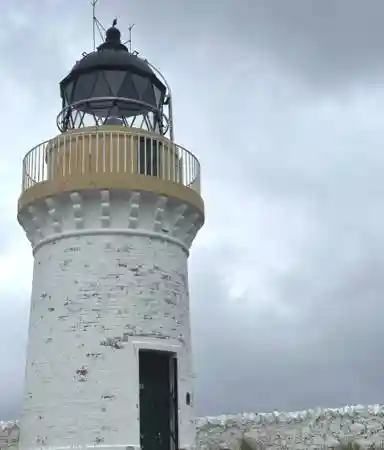
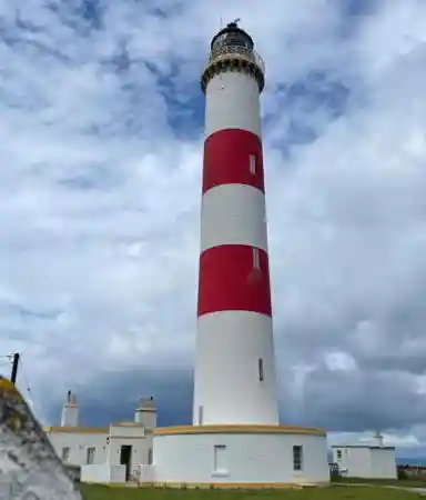
- Rubh
Reidh (Rua Reidh, Rubha Reidh, Rubh' Re)
- 1912 (David A. Stevenson). Active; focal plane 37 m (120 ft); four white
flashes, separated by 2.1 s, every 15 s. 25 m (83 ft) round masonry tower
with lantern and gallery, attached to 2-story keeper's house. Lighthouse
painted white with buff trim, lantern black. The original Fresnel lens, gears and foghorn mechanism from the lighthouse are on display at the Gairloch Heritage Museum in Gairloch. Andrea Hielscher's 2022 photo is
at the top of this page, Lighthouse Accommodations has a page for the lighthouse, Trabas has a 2008 closeup by Arno Siering, Andrea Hielscher has a 2022 photo, Wikipedia has an article with a photo, Marinas.com has aerial
photos, and Google has a street view and a satellite
view. Rua Reidh is a prominent headland jutting into The Minch about
halfway between Stoer Head and the Isle of Skye. Automated in 1986, the
station was leased by Chris Barrett and Fran Cree, who have operated it
as a vacation inn since 1989. In 2014 the station was approved as a wedding venue. In 2016 the owners blocked the road to the lighthouse, complaining about too many ill-mannered visitors. This led to an extended controversy and negotiations between the owners and the community council, with no resolution as of March 2017. In July 2019 the light station was sold to new owners. Overnight accommodations are available. Visitors can hike to the lighthouse on the access road (6 miles round trip) but may be challenged if they stray off the road onto private property. Located on the headland about 5 km (3 mi)
north of Melvaig. Site open to polite hikers, tower closed. Operator: Northern
Lighthouse Board. Site manager: Rua
Reidh Lighthouse . ARLHS SCO-191; Admiralty A3900; NGA 3640.
|
Eilean a Chait Light, Loch Carron, October 2021
ex-Google Maps photo by David Booth
|
- Cailleach Head (1) (relocated to Scoraig)
- 1953. Inactive since 2001. 6 m (20 ft) octagonal cylindrical tower with lantern and gallery. Entire lighthouse is white. Nigel Hyde has a closeup 2024 photo, Chris Eilbeck also has a closeup photo, and Google has a satellite view. The lighthouse was relocated to the village of Scoraig, about 4 km (2.5 mi) southeast of the original location, and restored by volunteer effort as a tiny exhibition and heritage center. This remote village is accessible by boat but can only be reached on land by a 5 km (3 mi) hike from Badralloch. Site open, tower open to visitors (inquire locally). Site manager: Scoraig Community Association.
- [Cailleach Head (2)]
- Date unknown. Active; focal plane 60 m (196 ft); two white flashes
every 12 s. 5 m (16 ft) square skeletal tower clad with white aluminum
panels to provide a daymark. A 2012 photo is available, Richard Webb has a distant view from the sea, M.J. Richardson has a similar distant view, Trabas has a very distant view,
and Google has a satellite
view. Located on the tip of the peninsula separating Loch
Broom and Little Loch Broom, about 16 km (10 mi) west of Ullapool.
This site does not appear to be accessible by road. Operator: Northern
Lighthouse Board. ARLHS SCO-028; Admiralty A3887; NGA 3624.
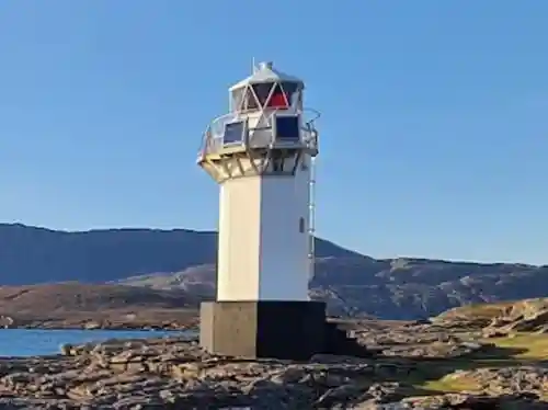
- * Rubha Cadail
(Rhue)
- 1952. Active; focal plane 11 m (35 ft); flash every 6 s, white,
red, or green depending on direction. 9 m (29 ft) octagonal cylindrical
tower with lantern and gallery, painted white. A 2023 photo is at right, Trabas has a 2007 photo,
Scott Young has a closeup,
Peter Davenport has a 2022 photo, Spencer has photos, Ian Capper has a photo, Marinas.com has aerial
photos, and Google has a satellite
view. The lighthouse is on the point separating Loch Kanaird
and Loch Broom, marking the north side of the entrance to
the upper portion of Loch Broom and the harbor of Ullapool.
Accessible by a short walk from the village of Rhue, off the
A835 highway about 5 km (3 mi) north of Ullapool.
Also accessible by a shoreline hiking trail from Ullapool,
a walk of about 10 km (6 mi), and there should be a good view
from ferries between Ullapool and Stornaway on the Isle of
Lewis. Site open, tower closed. Operator:
Ullapool
Harbour Trust. . ARLHS SCO-193; Admiralty A3885; NGA 3616.
|
Rubha Cadail Light, Ullapool, April 2023
Google Maps photo
by Major Nova
|
Sutherland Lighthouses
Sutherland is a historic county that shares the northernmost Scottish mainland with Caithness to the east. The name may seem inappropriate at first for such a northern region; it is derived from the Norse Suðrland, "southern land," so called because it is to the south of Orkney and Shetland.
* Stoer
Head (Rubha Stòr)- 1870 (David and Thomas Stevenson). Active; focal plane 59 m (194
ft); white flash every 15 s. 14 m (56 ft) round cylindrical stone
tower with lantern and gallery attached to a 2-story keeper's house.
Lighthouse painted white with buff trim, lantern black. The upper
floor of the keeper's house is available for vacation rental. Cornelius Ihssen's 2022 photo is at right, Trabas has Arno Siering's 2008 photo, Lighthouse Accommodations has a page for the lighthouse, C.W. Bash has a view
from the sea, Wikimedia has numerous photos, Marinas.com has aerial
photos, and Google has a street view and a satellite
view. In 2013 the NLB put the keeper's houses on sale for £210,000. The buyers renovated the building and made two units available for vacation rental. In April 2017 they put the improved property back on the market for £367,500. Located on the westernmost point of the Stoer peninsula
about 5 km (3 mi) west of Culkein. Accessible by road. Site open,
tower closed. Operator: Northern
Lighthouse Board. Site operator: Stoer Lighthouse
 . ARLHS SCO-226; Admiralty A3882; NGA
3600. . ARLHS SCO-226; Admiralty A3882; NGA
3600.
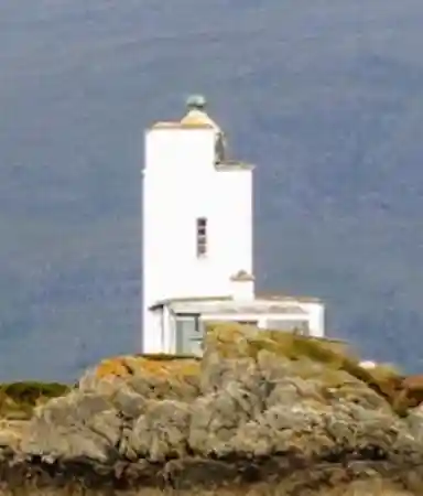
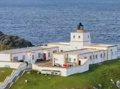
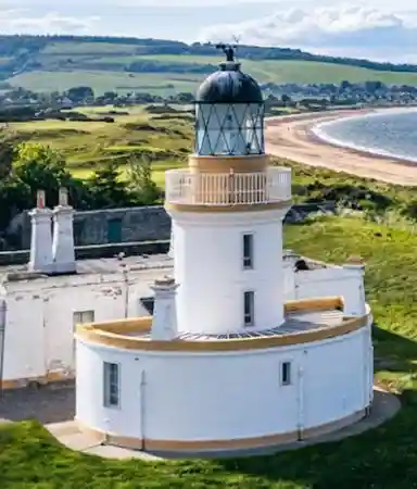
- * Cape Wrath (Am Parbh)
- 1828 (Robert Stevenson). Active; focal plane 122 m (400 ft); four
white flashes, separated by 2 s, every 30 s. 20 m (65 ft) round
granite tower attached to a 1-story keeper's house. Lighthouse painted
white, lantern black. Fog horn (3 blasts every 45 s). 1-story signal
station (1930s) adjacent to the light station. A 2023 photo by Stefan Loose appears at the top of this page, NLB has a page
for the lighthouse, Lighthouse Accommodations also has a page for the lighthouse, Anne Burgess has a good 2008 photo,
Trabas has a closeup 2008 photo
by Arno Siering, Simon Hudson has a 2022 photo, Wikimedia has numerous photos, Marinas.com has aerial
photos, Huelse has a historic postcard
view, Jacques van der Merwe has a 2017 street view, and Google has a satellite
view. This historic lighthouse marks the northwestern tip
of the Scottish mainland. The name of the cape seems appropriate for such as exposed and stormy location, but it actually comes from the Norse hvarf meaning "turning point." Much of the surrounding area is set
aside for military training and public access is tightly controlled.
However, guided tours via minibus
are available from Durness over a rough road 18 km (11 mi) long. The keeper's house is occupied
by resident caretakers, who opened a café for visitors
in 2009. Tours available daily May through September. Tower closed.
Operator: Northern
Lighthouse Board. . ARLHS SCO-039; Admiralty A3880; NGA 3576.
|
Stoer Head Light, Culkein, August 2022
Google Maps photo by Cornelius Ihssen
|
- [Loch Eriboll (Whiten Head) (2)]
- 2003 (station established 1894). Active; focal plane 19 m (62 ft); flash
every 10 s, white or red depending on direction. 5 m (16 ft) skeletal tower
clad with white aluminum panels to provide a daymark. David Glass has a closeup photo, Trabas has Eckhard Meyer's 2013 photo, Spencer has a photo, Barry Gannon has a 2020 photo, and Google has a satellite view. Located on a headland in the eastern entrance to the loch about
8 km (5 mi) north of Inverhope on the north coast of Scotland. Accessible only by boat. Site and tower closed. Operator: Northern
Lighthouse Board. ARLHS SCO-126; Admiralty A3874; NGA 3580.
- Strathy
Point
- 1958 (P.H. Hyslop). Inactive since 2012. 14 m (46 ft) square cylindrical masonry tower rising from a 1-story
keeper's house complex. Buildings painted white with buff trim; lantern
painted black. Kevin Newman's 2023 photo is at right, Karl Heinz has a good photo,
Rog Frost has a view, Marinas.com has aerial
photos, Patrick Reinders has a street view, and Google has a satellite
view. Last built of the traditional Northern Lighthouse Board lighthouses,
this light filled in a large gap in lighting the north coast of Scotland.
It was deactivated in March 2012, to the dismay of local residents. In July the station was for sale for £75,000 (a bargain price). The property sold in April 2013 and the buyer has opened the principal keeper's house for vacation accommodations. In 2022 the north keeper's cottage was for sale for £140,000. Located at the end of a long promontory on the central north coast, about
6 km (4 mi) north of Strathy. Accessible by road off the A836 highway
just west of Strathy. Site and tower closed (private property). Owner/site manager: private. . ARLHS SCO-227; ex-Admiralty A3590; ex-NGA 3048.
|
Strathy Point Light, Inverhope, February 2023
ex-Google Maps photo by Kevin Newman
|
Caithness Lighthouses
The historic county of Caithness occupies the extreme northeastern corner of the Highlands, with a northern coast facing Orkney across Pentland Firth and an eastern coast facing the North Sea.
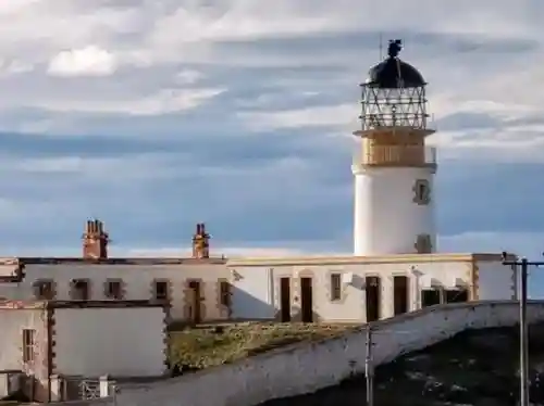
* Holburn
Head (Scrabster)- 1862 (David and Thomas Stevenson). Inactive since 2003. 17 m (56 ft) octagonal
cylindrical masonry tower rising from one end of a 2-story keeper's house.
The lighthouse was deactivated in August 2003 after alterations to the port
of Scrabster made its light misleading. A 2019 closeup is at right, Elisabeth Burton has a photo,
Cailean Macleod has a 2008 photo,
Marinas.com has aerial
photos,
Huelse has a historic postcard
view, and Bing has a satellite
view. When Ken Trethewey visited the station
in March 2003 he found the principal keeper's house unoccupied and in poor
condition. The lighthouse was sold as private residence, and the owners put it in good condition; it appears in excellent condition in the 2019 photo at right. In 2015 the light station was for sale for £190,000 and in 2025, following a renovation, it was back on sale for £450,000. The light is actually not on Holburn Head itself but is about
1 km (0.6 mi) south, on the north side of Scrabster. Accessible by car;
also clearly visible from ferries between Scrabster and Stromness in Orkney. Site and tower closed.
Owner/site manager: private. . ARLHS
SCO-097; ex-Admiralty A3578.
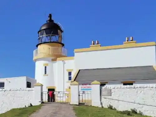
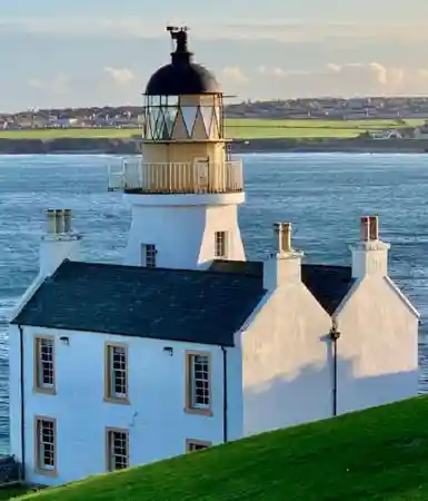
- * Dunnet
Head
- 1831 (Robert Stevenson). Active; focal plane 105 m (344 ft); four white
flashes every 30 s. 20 m (66 ft) round masonry tower with lantern and gallery.
1-story keeper's house and other light station buildings, including an inactive
square fog signal tower still carrying its diaphone horn. Trabas has a
closeup 2007 photo by Ian Wright, Lighthouse Accommodations has a page for the lighthouse, a 2020 closeup is available, Jonathan Billinger has a good photo of the station, Marinas.com has aerial
photos,
Patrick Bischoff has a street view, and Bing has a satellite
view. This handsome lighthouse marks the northernmost point of the mainland
of Great Britain and the western entrance to Pentland Firth, the strait beween Orkney and the mainland. World War II fortifications stand near the lighthouse.
Located atop a vertical cliff at the northern point of the Dunnet Head peninsula, about
6 km (4 mi) north of Brough at the end of secondary road B855. Parking provided.
Site and tower closed, but the lighthouse can be viewed from outside the
wall of the compound. Operator: Northern
Lighthouse Board. . ARLHS SCO-063; Admiralty A3574; NGA 3040.
- Stroma
(Swilkie Point)
- 1896 (David A. and Charles Stevenson). Active; focal plane 32 m
(105 ft); two white flashes, separated by 4 s, every 20 s. 23 m
(75 ft) round masonry tower with lantern and gallery, attached to
a 1-story keeper's house. 4th order Fresnel lens transferred from Sule Skerry in 1996. Fog horn (2 blasts every 60 s). Buildings
painted white with buff trim; lantern painted black. Lighthouse Accommodations has a page for the lighthouse, a 2017 photo and a 2007 helicopter view are available, Trabas has Capt. Peter Mosselberger's 2024 photo,
Marinas.com has aerial
photos, Huelse has a historic postcard
view, and Bing has a satellite
view. Stroma is an uninhabited island in Pentland Firth about
5 km (3 mi) northwest of John-o'-Groats, and the Swilkie is
a notorious whirlpool formed by conflicting tidal currents north
of the island. The lighthouse was built to warn ships to stay
clear of this very dangerous area. Located on the north point
of the Isle of Stroma. Accessible only by boat; the owner of
the island is said to offer tours from John-o'-Groats on summer
weekends. Site open, tower closed. Operator: Northern
Lighthouse Board. . ARLHS SCO-228; Admiralty A3568; NGA 3032.
|
Holburn Head Light, Scrabster, October 2019
Google Maps photo by Following The Lights
|
- * Duncansby
Head (John-o'-Groats)
- 1924 (David Alan Stevenson). Active; focal plane 67 m (220 ft);
white flash every 12 s. 11 m (36 ft) square concrete tower with
lantern and castellated gallery, originally attached to a 2-story
keeper's house. Buildings painted white with buff trim; lantern
painted black. Wikimedia has many photos, Lighthouse Accommodations has a page for the lighthouse, Trabas has a 2007 photo,
a 2023 photo is available, Rutwik Chandorkar has a nice 2022 photo, Marinas.com has aerial
photos, and Google has a street view and a satellite view. In the summer of 2005 extensive renovations replaced
the keeper's house with a much smaller 1-story structure. Huelse
has a historic postcard
view showing the original appearance of the station. The
light station marks the extreme northern end of Scotland's east
coast and the southeastern entrance to Pentland Firth, which
separates the mainland from the islands of Orkney. In the fall of 2018 NLB restored the lighthouse and replaced the Fresnel lens with an LED optic. Located atop
a spectacular vertical cliff about 5 km (3 mi) east of the village of John-o'-Groats. Accessible
by road. Site open, tower closed. Operator: Northern
Lighthouse Board. . ARLHS SCO-062; Admiralty A3558; NGA 3016.
- Noss
Head
- 1849 (Alan Stevenson). Active; focal plane 53 m (174 ft); white or red
flash, depending on direction, every 20 s. 18 m (59 ft) round masonry tower
with lantern and gallery, attached to a 1-story keeper's house. A 2nd order
Fresnel lens from this lighthouse (Scotland's oldest intact Fresnel lens) is on display with its working rotating mechanism at the Wick
Heritage Centre in Wick. Lighthouse painted white, lantern black. Tom Young's 2022 photo is at right, Trabas has a 2007 closeup,
Lighthouse Accommodations has a page for the lighthouse, a 2020 photo is available, Tom Young has a 2022 closeup, Marinas.com has aerial
photos,
Huelse has a historic postcard
view, Google has a distant street view, and Bing has a satellite
view. The
light station buildings were bought in 2006 by the Clan Sinclair as a library
and historical research
center, with the principal keeper's house available for vacation rental.
In 2016 the Clan put the principal keeper's house on sale for £85,000 and in 2018 it was sold to Benedicta Makin, an IT consultant from Edinburgh. An assistant keeper's cottage was for sale in 2022 for £119,000. The lighthouse may be endangered; the satellite view shows that
it is perilously close to the edge of the cliff. Located about 4 km (2.5
mi) northeast of Wick, marking the southern entrance to Sinclair's Bay.
Site and tower closed. Operator: Northern
Lighthouse Board. Site manager: private. . ARLHS SCO-157; Admiralty A3544; NGA 3012.
- * Wick
North Pier
- 1910. Inactive. Approx. 12 m (39 ft) hexagonal iron skeletal tower with
lantern and gallery. Lantern and upper half of the legs painted white, lower
half of legs painted brown. A closeup photo is available, Simon Verheire has a 2022 street view, and Google has an indistinct satellite view. This was originally the rear light of a range with the South Pier light as the front light. The town of Wick was formerly the county seat of Caithness. Located midway on the pier. Site open, tower
closed. Site manager: Wick Harbour
Authority.
ARLHS SCO-342.
|
Noss Head Light, Wick, August 2022
Google Maps photo by Tom Young
|
- * Wick
South Pier
- 1897. Active; focal plane 12 m (39 ft); flash every 5 s: directional
light, showing white over the entrance channel, red or green to
the sides. 11 m (36 ft) octagonal masonry lighthouse with lantern
and gallery, painted white. Fog bell (2 quick strokes every 10 s).
Trabas
has a closeup 2007 photo,
David Martin has a photo, Stanley Howe has a photo of the lighthouse and harbor, Marinas.com
has aerial photos,
Huelse has a historic postcard
view, Simon Verheire has a 2022 street view, and Google has a satellite
view. Located at the end of the pier sheltering Wick Harbour.
Accessible by walking the pier. Site open, tower closed. Operator: Wick Harbour Authority. . ARLHS
SCO-313; Admiralty A3528; NGA 3000.
- Clyth
Ness (Clythness)
- 1916 (David Alan Stevenson). Inactive since 2010. 13 m (42 ft)
round cylindrical masonry tower with gallery, painted
white with a single red horizontal band. The lantern was removed around 2015. 1-story keeper's house (private residence).
Michael Beales has a 2013 photo,
Devkanta Sharma has a 2022 photo, Angel Abalos has a view of the station, Marinas.com has aerial
photos, and Google has a satellite view and a very distant street view. The light was built at the Royal Navy's request to guide its ships during World War I. The light was discontinued on 18 March 2010. Located
atop a cliff about 5 km (3 mi) northeast of Lybster, just off
the A99 coastal highway. Site and tower closed (the access road is gated but the gates are open in Google's 2022 street view). Owner/site manager: private. ARLHS
SCO-048; ex-Admiralty A3524; ex-NGA 2996.
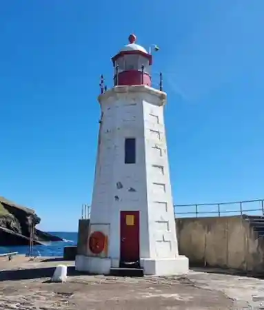
- * Lybster
(South Pier)
- 1884. Active; focal plane 10 m (33 ft); red light occulting once
every 6 s. Approx. 10 m (33 ft) octagonal stone tower with lantern
and gallery, painted white with red trim; lantern painted red with
a white dome. A 2022 photo is at right, Trabas has a
2008 photo
of the tower by Arno Siering, Bryan Eveleigh has another fine photo,
Google has a 2021 street view, and Bing has a satellite
view. Formerly a major fishing port, Lybster now caters more to tourism and recreational boating; a visitor center has summer programs. Located at the foot of the pier sheltering Lybster Harbour.
Accessible by car. Site open, tower closed. Operator: Lybster
Harbour Trust. . ARLHS SCO-299; Admiralty A3522; NGA 2988.
|
Lybster Light, Lybster, August 2022
Google Maps photo
by Gw2 Chief
|
Easter Ross Lighthouses
Easter Ross, the eastern region of the historic county of Ross and Cromarty, includes the mainland coast on the west shore of Moray Firth north of Inverness. Unlike most firths Moray Firth is not a narrow passage; it is a broad, wedge-shaped bay indenting northeastern Scotland.
Tarbat
Ness- 1830 (Robert Stevenson). Active; focal plane 53 m (174 ft); four white
flashes, separated by 2.1 s, every 30 s. 41 m (135 ft) round masonry tower
with lantern and gallery, painted with red and white horizontal bands; lantern
painted black. 1-story keeper's houses and other light station buildings.
The 3rd order Fresnel lens used from 1892 to 1984 is displayed at the National Maritime Museum in Greenwich. A 2023 photo is at right, Lighthouse Accommodations has a page for the lighthouse, Trabas has a 2007 photo,
Ewan MacLeod has a 2008 photo,
Steven Brown has a good photo, Jeanne Rowantree has a 2020 photo, Marinas.com has aerial
photos,
Huelse has a historic postcard
view, and Google has a 2021 street view and a satellite view. The lighthouse, the third tallest in Scotland, stands on the sharp
point separating Dornoch Firth from Moray Firth. Located about 5 km (3
mi) northeast of Portmahomack. Site and tower closed; the lighthouse can be viewed from a distance. Operator: Northern
Lighthouse Board. . ARLHS SCO-236; Admiralty A3506; NGA 2984.
- Nigg Oil Terminal
- Date unknown. Active (privately maintained); focal plane 31 m (102 ft);
green light occulting once every 5 s. 27 m (89 ft) square cylindrical skeletal
tower. Trabas has Rainer Arndt's 2019 photo and Google has a satellite
view and a distant street view across the firth. Located at the end of the terminal's jetty, which projects about
600 m (3/8 mi) into the north side of Cromarty Firth about 3 km (1.8
mi) west of the entrance. Site and tower closed, but there are views
from the ferry between Cromarty and Nigg. Operator/site manager: Nigg Oil Terminal. Admiralty A3493; NGA 2952.
- Dalmore Pier
- Date unknown. Inactive since 2017. 5 m (17 ft) square cylindrical unpainted brick and concrete tower. Les Ross has a 2012 photo, Spencer has a photo, and Google has a satellite view. Located at Dalmore on the north side of Cromarty Firth. Site status unknown. ex-Admiralty A3500.
- ** Cromarty (Crombagh)
- 1846 (Alan Stevenson). Inactive since 2006. 13 m (42 ft) round
cylindrical masonry tower with lantern and gallery, rising from
1-story keeper's house. Building painted white with buff trim; lantern
painted black. Sibling of Chanonry Light. Since 1990 the keeper's house and
outbuildings have been occupied by an ecology field station of the
University of Aberdeen. Jill Stevens has a 2022 photo, Tom Richardson has a good 2008 photo,
Marinas.com has aerial
photos, Huelse has a historic postcard
view, and Google has a 2023 street view and a satellite
view. The light was discontinued on 28 February 2006. In
April 2007 the lighthouse tower was offered for sale by the
Northern Lighthouse Board and in August 2009 it was sold to
the University. Located on George Street in Cromarty, a small town on the
south side of the entrance to Cromarty Firth. Site open, field
station open during business hours, tower closed. Owner/site manager: University
of Aberdeen (Lighthouse Field Station). . ARLHS SCO-056; ex-Admiralty
A3490; ex-NGA 2940.
|
Tarbat Ness Light, Portmahomack, July 2023
ex-Instagram photo by andys_clicks
|
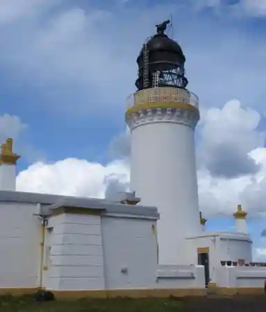
- * Chanonry (Cananaich)
- 1846 (Alan Stevenson). Active; focal plane 12 m (40 ft); white
light, occulting once every 6 s. 13 m (42 ft) round cylindrical
masonry tower with lantern and gallery, rising from a 1-story keeper's
house. Building painted white with buff trim; lantern painted black.
Maciej Olszewski's 2022 photo is at right, Lighthouse Accommodations has a page for the lighthouse, Trabas has a 2007 photo,
Gonzalo Gonzalez has a 2017 photo, Marinas.com has aerial
photos, and Google has a 2023 street view and a satellite
view. Chanonry Ness is a sharp point at the end of a sandy
spit projecting southward into Moray Firth at the beginning
of the approach to Inverness. Located at the end of Ness Road
2.5 km (1.5 mi) southeast of Fortrose; accessible by car. Site
open, tower closed. Operator:
Northern Lighthouse Board. . Admiralty
A3440; NGA 2900.
-
Inverness Lighthouse
- Located at the mouth of the River Ness, Inverness is a city of about 60,000 residents. As the administrative center for the Highland Council it is regarded unofficially as the capital of the Highlands.
* Craigton
Point (2)- 2002 (station established 1904). Active; focal plane 6 m (20 ft);
flash every 4 s, white, red or green depending on direction. 7 m
(23 ft) octagonal 1-story building with a pyramidal roof; the light
is mounted on a balcony. The building, a Royal National Lifesaving
Institution lifesaving station, is painted white; roof is black.
Trabas has a
photo,
another good closeup photo
is available, and Google has a closeup 2021 street view and a good satellite
view. This light guides vessels eastbound from Beauly Firth into Moray Firth. Located on a promontory at North Kessock, on
the north side of the firth almost under the Kessock
Bridge. Site open, tower closed. Site manager: RNLI
Kessock Station. Admiralty A3446; NGA 2916.
-
Nairnshire Lighthouse
- * Nairn
East Pier
- 1932. Active; focal plane 6 m (20 ft); white, red or green light
depending on direction, 3 s on, 1 s off. 5 m (17 ft) octagonal concrete
tower; the light is mounted on the roof. Tower painted white. Trabas
has a closeup,
Vicky Brock has a good photo,
Marinas.com has aerial
photos, and Google has a 2021 street view and a satellite view. Located at the end of the east (longer) breakwater
at Nairn; accessible by walking the pier. Site open, tower closed.
Admiralty A3436; NGA 2892.
|
Chanonry Light, Fort George, June 2022
Google Maps photo
by Maciej Olszewski
|
Caledonian Canal Lighthouses
Loch Linnhe and the Caledonian Canal combine to provide a sheltered waterway about 130 km (80 mi) long extending through the heart of the Scottish Highlands. The waterway connects
Oban and the Firth of Lorn on the west coast with Inverness and Moray
Firth on the northeast coast. It follows the Great Glen, a valley created by a major fault line cutting across Scotland. Historically the Glen was part of Inverness-shire.
* Bona
Narrows (Bona Ferry) - 1919. Inactive. Approx. 10 m (33 ft) octagonal building,
painted white, with an octagonal pyramidal roof; the light was shown
through a square window of the upper story. Ian Beange has the closeup 2021 photo at right, Des Colhoun has a 2009 photo, Robert
Dunn also has a photo,
and Google has a satellite
view. Trabas has a photo of the active light (focal plane 6 m (20 ft); two continuous white lights
mounted one above the other on a 6 m (20 ft) steel mast). In 2006
plans were announced to restore the lighthouse and build a visitor
center with a craft shop and restaurant on adjoining, privately owned
land. These development plans were fiercely opposed by some residents
of the area and the plans were abandoned. In September 2008 David
Stewart, a member of the Scottish Parliament, called for action to save the deteriorating lighthouse. In March 2009 Scottish Canals announced a plan to restore the building and make it available
for holiday accommodations. In August 2010 £380,000 in grants
for restoration were announced and the reopening of the lighthouse
was scheduled for 2012. This did not happen, and in July 2013 the BBC reported that an additional £30,000 was needed for the project. In September 2013 it was announced that the restoration and conversion would go forward as a £450,000 project. Craig Wallace's 2014 photo shows the restoration in progress. The renovation was finally completed in December 2014 at a total cost of £497,000, and the house is now available for vacation rental. Located at the northeastern end of Loch Ness in Lochend, marking the west side of the canal's northbound exit from
Loch Ness to its smaller extension, Loch Dochfour, about 11 km (7
mi) southwest of Inverness. Site open, tower closed. Operator: Inverness Hotels (Bona Lighthouse). . ARLHS SCO-347. Active light: Admiralty A3470.
|
Bona Light, Lochend, June 2021
ex-Google Maps photo by Ian Beange
|
- * Fort
Augustus
- 1840. Active; focal plane 9 m (30 ft); green flash every
3 s. 6 m (20 ft) round cylindrical tower, painted white, with a
black conical roof. The light is shown from a square window near
the top of the tower. Trabas has a photo,
Tom Reed has another photo,
and Google has a street view and a canal view, but overhanging trees block our view of the lighthouse in Google's satellite
view. This lighthouse and
the next two are called "pepperpots"
and are claimed to be the smallest lighthouses in Britain (there
are other claimants for this title). Located at the southwestern end of Loch Ness in
Fort Augustus, marking the east side of the canal's southbound
exit from Loch Ness to a series of five locks. Accessible by a
walking path. Site open, tower closed. Operator: Scottish Canals. . ARLHS SCO-350; Admiralty A3472.
- * Gairlochy
- 1932. Active; focal plane 7 m (23 ft); flash every 3 s,
white or green depending on direction. 6 m (20 ft) round cylindrical
tower, painted white, with a black conical roof. The light is shown
from a square window near the top of the tower. Trabas has a photo,
John Allan has a good photo,
Royston Vasey also has a photo,
Ron Hoebe has a 2022 photo, and Google has a street view and a satellite
view.
Located on the south side of the canal's southbound exit from
Loch Lochy about 800 m (1/2 mi) northeast of the locks at Gairlochy;
accessible by a short walking path. Site open, tower closed.
Operator: Scottish Canals. . ARLHS SCO-322; Admiralty A3480.
- * Corpach
- 1819. Active; focal plane 6 m (21 ft); white, red, or green light,
depending on direction, 2 s on, 2 s off. 6 m (21 ft) round cylindrical
masonry tower, painted white, with a black conical roof. The light
is shown from a square window near the top of the tower. Axel Becker's 2023 photo is at right, Steve Fareham has a 2013
photo, Marian Jones has a sunset photo, Trabas has a 2006 closeup by Ian Wright, and Google has a street view and a satellite
view. Located on the north side of the entrance
to the Caledonian Canal from Loch Linnhe in Corpach, about 3 km
(2 mi) north of Fort William. Accessible by a walking path. Site
open, tower closed. Operator: Scottish Canals. . ARLHS SCO-320; Admiralty A4140; NGA 4092.
|
Corpach Light, Corpach, June 2023
Google Maps photo by Axel Becker
|
Posted October 19, 2004. Checked and revised July 20, 2025. Lighthouses: 45. Site copyright 2025 Russ Rowlett and the University
of North Carolina at Chapel Hill.
.jpg)