| Dukono | |
|---|---|
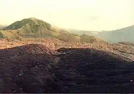 ash-blanketed crater floor of Dukono | |
| Highest point | |
| Elevation | 1,335 m (4,380 ft) [1] |
| Coordinates | 1°41′58.218″N 127°52′41.178″E / 1.69950500°N 127.87810500°E [1] |
| Geography | |
| Geology | |
| Mountain type | Complex volcano |
| Last eruption | 2021[2] |
Dukono is an active volcano located in the northern part of Halmahera island, Indonesia. It has a broad profile and is capped by compound craters. During the major eruption in 1550, a lava flow filled in the strait between Halmahera and the north flank cone of Mount Mamuya.[1] It was an eruption of scale 3 on VEI. Deaths were reported but the figure is unknown. Smaller eruptions occurred in 1719, 1868, and 1901.[3] Since 1933, Dukono has been erupting continuously until the present.[1]
Eruptions in 2014 increased since early spring. Ash clouds rose up to 2.5 km (1.6 mi) height and volcanic lightning were observed and photographed on June 11. Strombolian eruptions spew lava bombs on the outer flank of the crater cone.
See also
References
- ^ a b c d "Dukono". Global Volcanism Program. Smithsonian Institution. Retrieved 2006-12-13.
- ^ "Dukono volcano". 19 Feb 2018.
- ^ "Dukono, Halmahera Arc Volcanoes, Indonesia". Volcano World. Archived from the original on 2008-06-16. Retrieved 2010-09-01.
External links
![]() Media related to Dukono at Wikimedia Commons
Media related to Dukono at Wikimedia Commons
This article is copied from an article on Wikipedia® - the free encyclopedia created and edited by its online user community. The text was not checked or edited by anyone on our staff. Although the vast majority of Wikipedia® encyclopedia articles provide accurate and timely information, please do not assume the accuracy of any particular article. This article is distributed under the terms of GNU Free Documentation License.