This article is about the district. For the regency, see Kuningan Regency. For the Balinese Hindu festival, see Galungan.
Kuningan | |
|---|---|
District | |
| Regional transcription(s) | |
| • Sundanese | ᮊᮥᮔᮤᮍᮔ᮪ |
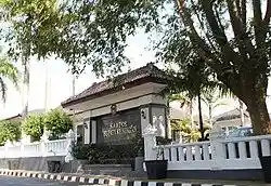 Regent Office of Kuningan Regency | |
| Etymology: Suranggajaya, Duke of Kuningan | |
| Coordinates: 6°58′35″S 108°29′4″E / 6.97639°S 108.48444°E | |
| Country | |
| Province | West Java |
| Regency | Kuningan Regency |
| Government | |
| • Camat | Saleh Rochiat |
| • Secretary | Dudi Sudiana |
| Area | |
| • Total | 29.75 km2 (11.49 sq mi) |
| Elevation | 534 m (1,752 ft) |
| Population (2020)[1] | |
| • Total | 95,362 |
| • Density | 3,200/km2 (8,300/sq mi) |
| Time zone | UTC+7 (IWT) |
| Postal code | 4551x, 45553 |
| Area code | (+62) 231 |
| Villages | 16 |
| Website | Official website |
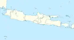
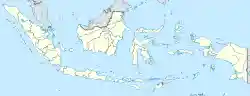
Kuningan (Sundanese: ᮊᮥᮔᮤᮍᮔ᮪) is a town and district located in eastern West Java, Indonesia, between Cirebon and Tasikmalaya, about 200 km east of Jakarta. It is the administrative center of Kuningan Regency. The district is located east of Mount Cereme/Ciremai (3.078 m), the highest mountain in West Java. The eastern part of the district is a valley. The district's landmark is a horse, called Kuda Kuningan[2] and its motto is Kuningan Aman (Safe) Sehat (Healthy) Rindang (Leafy) Indah (Beautiful), abbreviated as Kuningan ASRI.[3]
Administrative divisions
Kuningan District is divided into 16 villages which are as follows:[1]
- Ancaran
- Awirarangan
- Cibinuang
- Cigintung
- Cijoho
- Ciporang
- Cirendang
- Citangtu
- Karangtawang
- Kasturi
- Kedungarum
- Kuningan
- Padarek
- Purwawinangun
- Winduhaji
- Windusengkahan
Climate
Kuningan has a tropical monsoon climate (Am) with moderate rainfall from June to September and heavy to very heavy rainfall from October to May.
| Climate data for Kuningan | |||||||||||||
|---|---|---|---|---|---|---|---|---|---|---|---|---|---|
| Month | Jan | Feb | Mar | Apr | May | Jun | Jul | Aug | Sep | Oct | Nov | Dec | Year |
| Average high °C (°F) | 28.4 (83.1) | 28.5 (83.3) | 28.8 (83.8) | 29.0 (84.2) | 29.2 (84.6) | 28.9 (84.0) | 28.5 (83.3) | 28.9 (84.0) | 29.6 (85.3) | 30.0 (86.0) | 29.3 (84.7) | 28.9 (84.0) | 29.0 (84.2) |
| Daily mean °C (°F) | 24.3 (75.7) | 24.3 (75.7) | 24.5 (76.1) | 24.6 (76.3) | 24.8 (76.6) | 24.2 (75.6) | 23.8 (74.8) | 23.9 (75.0) | 24.4 (75.9) | 25.0 (77.0) | 24.7 (76.5) | 24.6 (76.3) | 24.4 (76.0) |
| Average low °C (°F) | 20.2 (68.4) | 20.1 (68.2) | 20.2 (68.4) | 20.3 (68.5) | 20.4 (68.7) | 19.5 (67.1) | 19.1 (66.4) | 18.9 (66.0) | 19.2 (66.6) | 20.0 (68.0) | 20.2 (68.4) | 20.3 (68.5) | 19.9 (67.8) |
| Average rainfall mm (inches) | 462 (18.2) | 392 (15.4) | 443 (17.4) | 278 (10.9) | 218 (8.6) | 109 (4.3) | 80 (3.1) | 52 (2.0) | 58 (2.3) | 133 (5.2) | 267 (10.5) | 382 (15.0) | 2,874 (112.9) |
| Source: Climate-Data.org[4] | |||||||||||||
References
- ^ a b c d "Kuningan Subdistrict in Figures 2020". Statistics Indonesia. Retrieved December 9, 2020.
- ^ "Lambang Daerah | Pemerintah Kabupaten Kuningan". www.kuningankab.go.id (in Indonesian). Retrieved 2018-11-17.
- ^ "Sasanti Daerah dan Moto Juang Kuningan | Pemerintah Kabupaten Kuningan". www.kuningankab.go.id (in Indonesian). Retrieved 2018-11-17.
- ^ "Climate: Kuningan". Climate-Data.org. Retrieved 12 November 2020.
This article is copied from an article on Wikipedia® - the free encyclopedia created and edited by its online user community. The text was not checked or edited by anyone on our staff. Although the vast majority of Wikipedia® encyclopedia articles provide accurate and timely information, please do not assume the accuracy of any particular article. This article is distributed under the terms of GNU Free Documentation License.