Also found in: Encyclopedia.
This article is about a river. For the village, see Minija (village).
| Minija | |
|---|---|
.jpg) Map highlighting Minija | |
| Location | |
| Country | Lithuania |
| Physical characteristics | |
| Source | |
| • location | Lake Didovas |
| Mouth | |
• location | Neman |
• coordinates | 55°20′49″N 21°17′33″E / 55.3469°N 21.2925°E |
| Length | 202 km (126 mi) |
| Basin size | 2,978 km2 (1,150 sq mi) |
| Discharge | |
| • average | 38.7 m3/s (1,370 cu ft/s) |
| Basin features | |
| Progression | Neman→ Baltic Sea |
Minija is a river in western Lithuania and a tributary to Nemunas. It is 202 km (126 mi) long.[1] It begins from small Lake Didovas, and hydrographically from lake Sydeklis, 14 km south of Telšiai. The rivulet that flows out of Sydeklis here is called Mava, in between Lake Ilgis and Lake Pluotinalis - Kliurkė and only after Lake Didovo it gets the Minija name.
It flows through Lakes Ilgis, Pluotinalis, Didovas, and Gargždai, Priekulė towns before reaching the Atmata distributary of the Nemunas delta.
In 1873 a channel, called "Vilhelmo kanalas" was built that connected Minija directly with Klaipėda port.
Tributary rivers
- Left: Pala, Alantas, Žvelsa, Agluona, Veiviržas, Tenenys
- Right: Sausdaravas, Babrungas, Mišupė, Salnatas
References
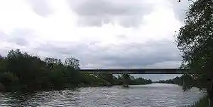
Minija near Kintai
This article is copied from an article on Wikipedia® - the free encyclopedia created and edited by its online user community. The text was not checked or edited by anyone on our staff. Although the vast majority of Wikipedia® encyclopedia articles provide accurate and timely information, please do not assume the accuracy of any particular article. This article is distributed under the terms of GNU Free Documentation License.