Rupa-Rupa
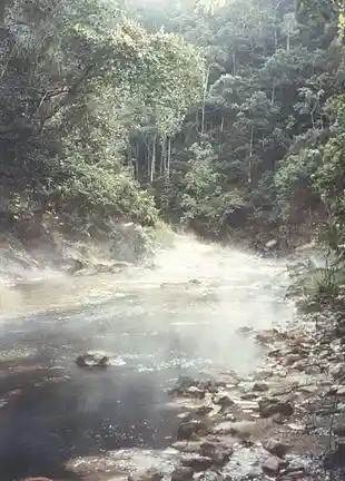
Hot springs in the Rupa-Rupa Region, Amazonas, Peru.
Rupa-Rupa or High Jungle is one of the eight natural regions of Peru. It is located between 400 and 1,000 m above the sea level to the east of the Andes mountain range in the Amazon basin of Peru. This region has many long, narrow valleys and fluvial mountain trails (canyons called pongos). The weather is warm, humid, and rainy.
This region has a tropical flora.
The fauna includes the Brazilian tapir (sachavaca, also called mountain cow), the white-lipped peccary (huangana), and the jaguar (otorongo).
Rupa Rupa is the hottest region in Peru.[1]
Overview
Andean Continental Divide
| Westside | Eastside |
|---|---|
| Chala, dry coast | Lowland tropical rainforest or Selva baja |
| Maritime Yungas | Highland tropical rainforest or Selva alta |
| Maritime Yungas | Subtropical cloud forest or Fluvial Yungas |
| Quechua – Montane valleys | Quechua – Montane valleys |
| Tree line | Tree line – about 3,500 m |
| Suni, scrubs and agriculture | Suni, scrubs and agriculture |
Mountain Top:
- Mountain passes – 4,100 m
- Puna grassland
- Andean-alpine desert
- Snow line – about 5,000 m
- Janca – Rocks, Snow and Ice
- Peak
See also
- Altitudinal zonation
- Climate zones by altitude
Literature
- ^ Pulgar Vidal, Javier: Geografía del Perú; Las Ocho Regiones Naturales del Perú. Edit. Universo S.A., Lima 1979. First Edition (his dissertation of 1940): Las ocho regiones naturales del Perú, Boletín del Museo de historia natural „Javier Prado“, n° especial, Lima, 1941, 17, pp. 145–161.
This article is copied from an article on Wikipedia® - the free encyclopedia created and edited by its online user community. The text was not checked or edited by anyone on our staff. Although the vast majority of Wikipedia® encyclopedia articles provide accurate and timely information, please do not assume the accuracy of any particular article. This article is distributed under the terms of GNU Free Documentation License.